ClearView Aerial Imagery
|
|
9890 N Loop Rd -
Pensacola,
FL
32507
clearviewaerialimagery.com
|
|
ClearView Aerial Imagery offers the highest quality aerial photography, videography and editing services at a price tailored to your specifications. Since projects oftentimes evolve as they unfold, we are prepared to work dynamically. The skilled pilots of ClearView can handle additional requests or challenges that may arise during production.
Based out of Pensacola, FL, our team is willing to travel at your convenience.
|
|
|
|
|
|
|
|
|
Stephen Buescher
- 609-760-2485
Founder
Services
Aerial Surveyors
Marine Surveyors & Adjustors
Photographers - Architecture & Real Estate
Photographers - Family Portraits
Photographers - Fine Art
and more...
|
|
|
|
|
|
|
|
Questions & Answers
|
|
Q:
|
What advice would you give to a customer looking to hire a company like yours?
|
|
A:
|
At the end of the day, make sure you get exactly what you want. There are plenty of companies out there with various levels of prices and all of them want your business. Don't pick one just because its cheap. Pick a group because they have what you need. If they are also cheaper, then that's a bonus.
|
|
|
Q:
|
What is the most common type of project or service your company provides?
|
|
A:
|
Terrain or building assessments tend to be the most common. We have a variety of cameras and filters that make looking for fractures, leaks, and damage easier to see on buildings, roads, walls, as well as in agriculture fields and parks. Using this information is easy to make a virtual map or model for our clients.
|
|
|
Q:
|
In what ways is your company environmentally friendly?
|
|
A:
|
A large part of our services revolve around terrain assessment, building inspection, and agricultural evaluations. We want to make sure that everyone is working efficiently, stopping waste and excess by both saving money and consolidating their existing uneccessary resources through our assessment programs. We've saved farmers, construction companies and engineer surveyors tens of thousands of dollars in excess spending, which leads to excess waste. All of our gear relies on reusable energy cells and is easy to repair small parts, minimizing damages and waste.
|
|
|
Q:
|
What would you like your customers to know about your company?
|
|
A:
|
Our services are highly adaptable to any project that you may need. Even if someone is unsure how to tackle something, we can likely find a cheap, reliable, and more accurate way to help in several capacities you may not even knew existed before. Our services can be useful and productive for just about any industry whether its promotional marketing shots to professional footage, from examining the land for a new building to watching sporting events, time lapse observations to thermal imagine, tracking objects to calculating large measurements, and the list goes on and on.
|
|
|
Q:
|
What is your company best known for?
|
|
A:
|
Drones are a new and developing technology and many people haven't had proper exposure to what they can do. Every new client we satisfy comes away saying that they had no idea drones could do all these things, or how it could have been as useful as it was to their project. We encourage everyone to give it a try.
|
|
|
Q:
|
What separates your company from the competition?
|
|
A:
|
We know that each project is different, even among the same industries. Our crews have a wide range or versatile skills and creative minds so that we can adapt to and change with each new project. Many clients don't fully understand what we are capable of, and they may change their minds mid mission for what they want. This happens all the time, and we not only are prepared for it but encourage them to do so. We can meet just about any vision a client may have.
|
|
|
Q:
|
Does your company offer a warranty or guarantee?
|
|
A:
|
Once hired for a project, we will continue to work with the client until they get exactly what they want, even if that means we do for more flights and editing than initially planned. Should we ever get an unsatisfied customer, it will cost them nothing.
|
|
|
Q:
|
What questions do customers most frequently ask you? What is your answer?
|
|
A:
|
Customers always ask what the price range is first. All of our services sound great and helpful and complicated, so they think it must be expensive. Not so. Each project is different, as is an individual's budget for the project. Our prices are drastically lower than any other method of aerial observation, and we bring far more to the table for that much lower cost. Drones streamline so much that we can afford to be cheap while out performing the competition.
|
|
|
Q:
|
Does your company offer discounts to senior citizens or veterans?
|
|
A:
|
If our services are involved in search and rescue or saving a life, we offer it freely to veterans and government employees. Our prices are already so low that any income level who needs a drone can easily pay for our work.
|
|
|
Q:
|
Tell us a little about your company.
|
|
A:
|
ClearView Aerial Imagery is a drone photography, videography, terrain assessment, and survey company. It is our belief that we can offer helpful, productive, and adaptable services that will lead to large savings and better virtual presence for any client in any industry. Our specialty is using cameras to not only take high quality footage, but to assess crops, damages, terrain, assist in search and rescue, show patters over time for construction, sports, traffic, weather, and create 3D models of just about anything. We can help everybody, and we'd love to do so.
|
|
|
Q:
|
What forms of payment do you accept? (cash, check, credit cards, etc.)
|
|
A:
|
Payment can come in just about any legally acceptable form, usually negotiated in advance of the project taking place.
|
|
|
|
|
|
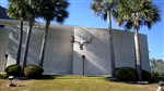
Project Gallery
|
ClearView Aerial Imagery
ClearView Aerial Imagery offers the highest quality aerial photography, videography and editing services at a price tailored to your specifications. Since projects oftentimes evolve as they unfold, we are prepared to work dynamically. The skilled pilots of ClearView can handle additional requests or challenges that may arise during production.
Based out of Pensacola, FL, our team is willing to travel at your convenience.
|
|
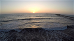
Ocean Beach Promotional
ClearView created an example promotional project for the Ocean Beach merchant groups in San Diego. The results were spectacular flyovers of beaches, cliffs, business districts and along waterfront properties.
|
|
Testimonials
|
|
|
How We Charge For Our Services
|
Aerial Surveyors
- $225.00 to $1,500.00 per hour
It depends greatly upon the project we are doing. basic real estate or photo shoots with just the raw footage is far cheaper than processing a terrain assessment map for several hundred acres of agriculture land, or inner city building inspections.
|
Photographers - Architecture & Real Estate
- $60.00 to $75.00 per hour
- $575.00 to $725.00 for half-day session
- $225.00 to $365.00 fixed fee (for standard 4 bedroom house)
Architecture and real estate require different timing and processes depending on their requests. Everything here is negotiable depending on the project.
|
Photographers - Family Portraits
- $50.00 to $65.00 per hour
- $225.00 per session
To provide flexible, yet consistent services to multiple industries ClearView charges prices based upon the type of processing/editing work, the number of flights, the number of pilots needed, and the amount of raw footage processed.
|
Photographers - Fine Art
- $50.00 to $80.00 per hour
"fine art" is vague and highly negotiable based upon the work involved.
|
Photographers - Generalist
- $50.00 to $65.00 per hour
- $225.00 to $375.00 per session
It depends on the project involved and what type of editing/processing of the footage is required. Everything is in 4K resolution, which requires more thorough post-flight work with certain features.
|
Photographers - Portraits, Headshot & Portfolio
- $50.00 to $65.00 per hour
- $150.00 to $375.00 per session
We like to work within the budget of the party and will alter prices based upon their desires and our work costs.
|
Photographers - Weddings & Special Occasions
- $50.00 to $65.00 per hour
- $375.00 to $2,000.00 fixed fee - flat rate
We have our own photographers and videographers, but are always willing to work with or under whoever the client has picked as their primary team. If we work in tandem with another group, they will have access to see our screens and direct our pilots to where they think is best.
|
Videography - Weddings & Events
- $50.00 to $65.00 per hour
- $350.00 to $800.00 fixed fee for wedding
We have our own videographers, but are always willing to work with or under other teams the client my pick as lead. Depending on our role and what is required, will determine the fee. All discussed beforehand with no obligations.
|
|
|
|
|
|
* All information in this profile, including licensing, has been provided by
ClearView Aerial Imagery. This information is not verified by ProMatcher.
|
|
|
|
|